
Those who are afraid of thunderstorms should move to Kiel, whereas those who do not feel threatened by thunder and lightning should settle in Garmisch-Partenkirchen, because average thunderstorm activity is lowest in the city in Northern Germany and highest in the city in Bavaria. Scientists of Karlsruhe Institute of Technology (KIT) evaluated data on thunderstorm occurrences and published their findings in the Natural Hazards and Earth System Sciences journal.
The frequency of thunderstorms may not only affect people’s nerves, but also burden their purse: “Heavy thunderstorms, in particular those associated with large hailstones, strong rains, and wind gusts, often cause considerable damage to buildings, vehicles, and agriculture,” says Michael Kunz of KIT’s Institute for Meteorology and Climate Research (IMK). Examples are the two very heavy thunderstorms in late July 2013 in Lower Saxony and South Germany. They caused damage in the amount of about EUR 3 billion. “This was the biggest insured damage caused by natural disasters worldwide in that year,” Kunz adds. According to data of reinsurance companies, severe thunderstorms caused a total damage of EUR 10.4 billion in the past five years.
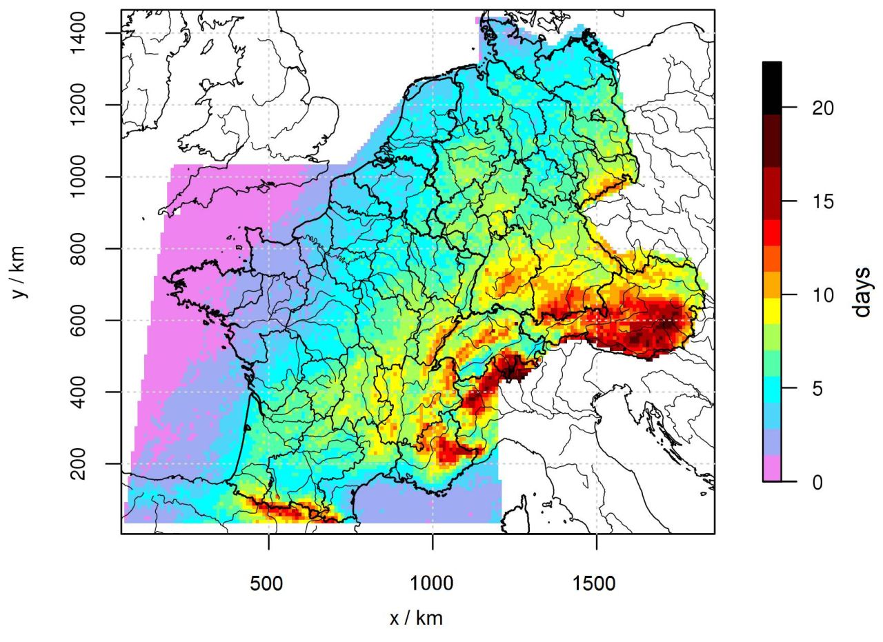
“Thunderstorm activity strongly depends on the region,” David Piper of IMK says. In Germany, the number of thunderstorm days, i.e. days with at least five flashes of lightning on an area of five times five square kilometers, is highest in the Prealps west and east of Garmisch-Partenkirchen. In the Bavarian Prealps, up to 15 thunderstorm days occur annually. Other high activities are found between the Neckar river and Swabian Jura, in the Ore Mountains, and in the Bavarian Forest. “The number of thunderstorm days is lowest along the coasts of the North and Baltic Seas,” Piper says. “In 2010, for example, there were no thunderstorms at all in the region between Hamburg and Bremen.” While there are an average of two thunderstorm days per year in Northern Germany, thunderstorm days amount to seven in the region of Karlsruhe. The high season of thunderstorm activity is from June to August with a peak in July. Thunderstorms mostly develop in the afternoon or early evening when temperatures are highest. (Bigger thunderstorm clusters that develop from large-area mechanisms or previous thunderstorms preferably occur during the night).
When including Austria, Switzerland, Benelux countries, and France, it can be seen that the number of thunderstorm days increases from Northwest to Southeast. It is highest in parts of the Southern Alps in Austria and a strip of land extending from the Ticino to the neighborhood of Turin. The absolute peak is found to be in the Steiermark region with 34 thunderstorm days in 2009.
Thunderstorm activity is determined by three factors: Distance from the sea, local landscape, and humidity close to the ground. “The sea has a thunderstorm-inhibiting influence, as water cools down and, hence, stabilizes the bottom air layers in summer,” Piper says. Mountainous terrain forces the air to ascend and facilitates thunderstorm development.
According to the weather experts, however, no increase or decrease of thunderstorm activity can be observed. Instead, thunderstorm activity varies strongly from year to year. These annual fluctuations are determined by large-area flow patterns and the sea surface temperature. In large parts of the investigation area, for instance, thunderstorm activity is strongly reduced by strong west wind. In future, the researchers plan to study this high annual variability that is of particular interest to insurance companies.
Reference: Piper, D. and M. Kunz, 2017: Spatiotemporal variability of lightning activity in Europe and the relation to the North Atlantic Oscillation teleconnection pattern. Nat. Hazards Earth Syst. Sci., 17, 1319–1336; doi: https://doi.org/10.5194/nhess-17-1319-2017
Additional material:
https://www.nat-hazards-earth-syst-sci.net/17/1319/2017/nhess-17-1319-2017.pdf
More about the KIT Climate and Environment Center: http://www.klima-umwelt.kit.edu/english
In close partnership with society, KIT develops solutions for urgent challenges – from climate change, energy transition and sustainable use of natural resources to artificial intelligence, sovereignty and an aging population. As The University in the Helmholtz Association, KIT unites scientific excellence from insight to application-driven research under one roof – and is thus in a unique position to drive this transformation. As a University of Excellence, KIT offers its more than 10,000 employees and 22,800 students outstanding opportunities to shape a sustainable and resilient future. KIT – Science for Impact.