

Water is one the most vital resources for humans, may it be in the form of drinking water or for irrigation in agriculture. In some regions that are facing water shortage problems today already, water supply is seriously threatened by climate change. At the same time, global water consumption is increasing. For developing and implementing drinking water concepts for cities in water-shortage regions, it is essential to have precise information on soils in river catchment areas. So far, this has been difficult in rough terrain in particular. Researchers of Karlsruhe Institute of Technology (KIT) are now working on an AI-based method to obtain reliable information on soil properties from aerial photos and satellite images.
“Some soil characteristics already are obtained with conventional image analysis methods. Parameters, such as soil moisture and soil type, however, can be determined by expensive sampling only,” says Felix Riese of KIT’s Institute of Photogrammetry and Remote Sensing (IPS). In rough terrain, this is difficult or even impossible. This is the point of departure of the physicist’s research project: “We are working on an artificial intelligence that determines information on soil moisture, vegetation type, or soil composition from satellite images and aerial photos only. These relationships often are so complex that they cannot be described by a conventional algorithm.
Our AI captures and interconnects these characteristics automatically.”
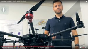
During a joint campaign with KIT’s Institute of Water and River Basin Management, which was coordinated by Riese, KIT researchers collected soil samples in Peru. In addition, they scanned the whole study area with a special camera fixed to a hexacopter. It records images in the hyperspectral range. The information obtained from such images exceeds the information provided by normal cameras by a factor of one hundred. “With these data, we train the AI until its evaluations of aerial photos are in agreement with the values measured by us.”
To use the method outside of the test region in Peru, Riese and his colleagues input data from other areas that are drier or have another vegetation. “When the AI is trained well, troublesome and expensive measurement campaigns in the regions are no longer required to obtain exact information on the state of the groundwater,” Riese says. The project goal is that a single satellite image will be sufficient. In future, such evaluation results might be used for the quicker and less expensive implementation of drinking water concepts in cities.
TRUST: Sustainable, Fair, and Ecologically Compatible Drinking Water Supply
Felix Riese’s research is part of the TRUST project, the contributions by KIT are coordinated by Sina Keller. Within this project, experts of various institutions and disciplines cooperate to develop novel, sustainable water supply and wastewater management concepts as well as integrated planning tools above all for drinking water supply. The water catchment area of the region of Lima/Peru is used as an example. The TRUST partners are Stuttgart University (coordination), KIT, the Water Technology Center, Disy Informationssysteme GmbH, decon International GmbH, Ingenieurbüro Pabsch & Partner, and Ingenieurgesellschaft mbH. The project is funded by the Federal Ministry of Education and Research (BMBF).
More about the KIT Climate and Environment Center: http://www.klima-umwelt.kit.edu/english
In close partnership with society, KIT develops solutions for urgent challenges – from climate change, energy transition and sustainable use of natural resources to artificial intelligence, sovereignty and an aging population. As The University in the Helmholtz Association, KIT unites scientific excellence from insight to application-driven research under one roof – and is thus in a unique position to drive this transformation. As a University of Excellence, KIT offers its more than 10,000 employees and 22,800 students outstanding opportunities to shape a sustainable and resilient future. KIT – Science for Impact.