
For blind and partially sighted people, it is difficult – and sometimes even risky – to move independently in unknown environments, above all in urban and busy areas. The feeling of insecurity and disorientation and the fear of accidents can considerably restrict the mobility and social integration of these individuals. The TERRAIN joint project is aimed at developing and testing a portable, electronic assistance system that will greatly extend their range of motion. The Federal Ministry of Education and Research has decided to fund this project with EUR 1.7 million.
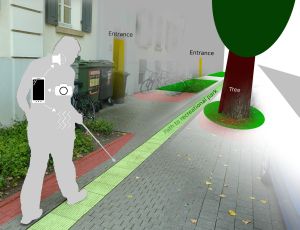
The system relies on mobile devices such as smartphones or smart watches. The usability of these devices for people having a sight impairment is steadily improving, they are more widely accepted by these persons now, and they provide important technologies such as GPS or voice input and output. “We want to leverage this potential to supplement the traditional aids such as the long cane,” project coordinator Sebastian Ritterbusch from iXpoint Informationssysteme GmbH explains. It is true that the so-called probing cane can only detect obstacles at floor level. This means that safe movements without the help of another person are only possible in familiar rooms and on previously learned routes.
Besides the mobile device, the system will include two other hardware components. A camera, placed at breast level of the bearer, captures the situation directly in front of the navigation device user – signs, cordons, persons – and sends them to the mobile phone for evaluation. On the mobile phone, in turn, digital map data is stored, e.g. from land registry offices, and pictures of certain environments, including typical landmarks, buildings, entrances and crossings. In addition, a “mobile Braille line” will provide detail information about the environment that can be read by the user.
For the project partners, the development of the man-machine interface is particularly challenging. “Everything that is recognized, matched, and analyzed by the system must be transferred to the user in a quick and user-friendly manner,” Rainer Stiefelhagen, Director of the KIT Study Centre for the Visually Impaired (SZS) explains. It is intended to test different variants of information transfer in the course of the project. The options include the transmission of voice messages or audible signals, or the use of vibrations that can be transmitted to the mobile phone, a smart watch, or a belt, indicating a direction.
In a first step, the project stakeholders will collect data for the configuration of the system and then create, in close collaboration with organizations supporting visually impaired persons and with mobility trainers, a requirements specification for the navigation device. It is intended to have an initial version of the system tested by volunteers around the end of 2015 and then continue its optimization. “Our system widens sensory perception,” as Ritterbusch and Stiefelhagen point out. “Its ultimate field of application will depend not least from the data which is available. But every step we take to improve the orientation by applying new methods means more safety and independence for the visually impaired users.”
About TERRAIN:
TERRAIN is a joint project coordinated by iXpoint Informationssysteme GmbH. At Karlsruhe Institut für Technologie (KIT), the project is partnered by the Study Centre for the Visually Impaired, the Computer Vision for Human-Computer Interaction Lab, and the Institute for Technology Assessment and Systems Analysis. Another partner is F.H. Papenmeier GmbH & Co. KG. The project has a volume of EUR 2.1 million and is funded 79 percent by the Federal Ministry of Education and Research, within the scope of a funding scheme on the man-machine-technology interaction for intelligent mobility: reliable technology for mobile users (IMO). The project will end on June 30, 2018.
For more information, please visit: http://www.terrain-projekt.de/
In close partnership with society, KIT develops solutions for urgent challenges – from climate change, energy transition and sustainable use of natural resources to artificial intelligence, sovereignty and an aging population. As The University in the Helmholtz Association, KIT unites scientific excellence from insight to application-driven research under one roof – and is thus in a unique position to drive this transformation. As a University of Excellence, KIT offers its more than 10,000 employees and 22,800 students outstanding opportunities to shape a sustainable and resilient future. KIT – Science for Impact.